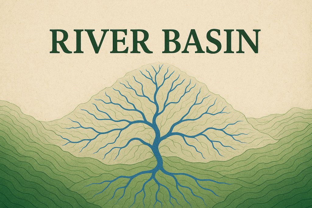
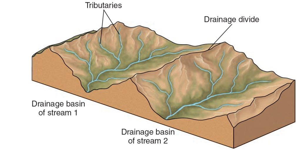
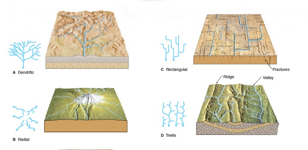
Each stream, small or large, has a drainage basin, the total area drained by a stream and its tributaries.
A drainage basin is more than just a mapmaker’s term—it’s the natural funnel through which all rainfall, melting snow, and underground springs find their way to rivers, lakes, and eventually the sea. Shaped by gravity and sculpted over millennia, each basin collects water from a vast landscape, guiding it along countless streams and tributaries toward a common outlet. From the tiniest mountain creeks to the mighty Amazon, every river owes its existence to the invisible architecture of its drainage basin—a living, breathing system that connects land, water, and life.
Drainage Basin- a Vast Network of Tributaries
In most rivers around the world, the true source of power doesn’t come from a single spring or mountaintop trickle—it comes from a vast network of tributaries. These smaller streams and rivers feed into the main channel, merging their waters like veins converging into an artery, building volume and strength as they go. A tributary is typically the smaller partner in this confluence, but nature doesn’t always play by clear-cut rules.

Sometimes, two rivers of similar size come together, and tradition alone decides which name survives the merger. In rare cases, the smaller stream retains its name, while the larger yields—a curious quirk of naming conventions rather than hydrological logic.
Tributaries and Drainage Basins: The River’s Expanding Web
This web of tributaries forms what’s known as a drainage basin—the entire land area where precipitation collects and drains into a single river system. You can trace it on a map by drawing a line around all the terrain funnelling water into that river and its many tributaries.

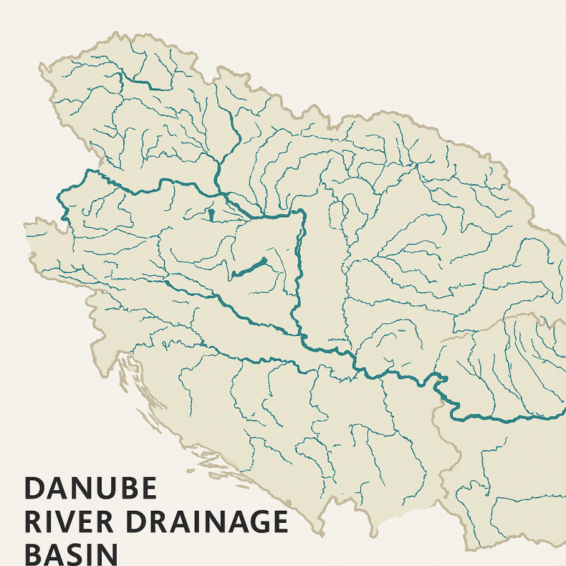
Take the Danube River, for instance. Its drainage basin sprawls across much of Central and Eastern Europe, gathering waters from major rivers like the Tisza in Hungary and the Sava flowing from the Balkans. Similarly, the Mississippi River’s drainage basin is a colossus of North America, swallowing the flows of the Ohio and Missouri rivers and stretching across over one-third of the contiguous United States. These basins are not just collections of rivers—they’re sprawling, interconnected landscapes, shaped by water’s patient reach.
River Basin vs Catchment
While the terms river basin and catchment are sometimes used interchangeably, especially in casual conversation, they have slightly different meanings and uses, especially depending on context and region.
Here’s a clear breakdown:
🌊 Catchment
A catchment refers to the area of land where all water (rainfall, snowmelt, etc.) collects and drains toward a specific point—usually a river, stream, lake, or reservoir.
- It’s often used for smaller-scale systems.
- You can have multiple catchments within a larger river basin.
- Also known as a drainage area or watershed (especially in the U.S.).
- The term is frequently used in engineering, urban planning, and water resource management.
🧭 Think of a catchment as: “The land that catches the rain for a particular stream or small river.”
🌍 River Basin
A river basin is the entire area drained by a river and all of its tributaries, from its source to its mouth (e.g., ocean, lake).
- It’s a larger, more comprehensive concept.
- A river basin contains many smaller catchments.
- Typically used in regional planning, hydrology, and ecological studies.
- Often named after the main river (e.g., Amazon River Basin, Nile River Basin).
🧭 Think of a river basin as: “The full body of land that feeds a major river system.”
🧪 Example for Clarity:
Imagine you’re standing by a tiny creek that flows into a stream, which then joins a larger river:
- The small patch of land around that creek is its catchment.
- All the catchments of the creeks, streams, and tributaries together make up the river basin of the main river they feed.
🌐 Regional Terminology Differences:
- In British English: Catchment and catchment area are commonly used even for large rivers.
- In American English: Watershed is often used instead of catchment, and river basin for large systems.
🧭 In summary:
| Term | Scale | Focus | Example |
|---|---|---|---|
| Catchment | Small–medium | Specific water point | A creek’s catchment area |
| River Basin | Large | Whole river system | The Nile River Basin |
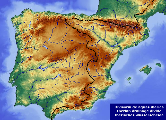
Divides and Watersheds: Where Rivers Part Ways
At the edges of every drainage basin lies an invisible line—sometimes subtle, sometimes dramatic—marking the boundary where water decides its fate. This high ground, whether a towering ridge or a gentle rise, is known as a divide. It’s the place where raindrops falling just a few feet apart may end up in entirely different oceans.

The most famous of these in the United States is the Continental Divide, a sprawling spine that splits the continent’s waters in two. On one side, rivers rush toward the Pacific Ocean; on the other, they wind their way to the Atlantic Ocean or the Gulf of Mexico. This divide stretches from the frozen expanses of the Yukon Territory in Canada all the way into Mexico, cutting through states like Montana, Idaho, Wyoming, Colorado, and New Mexico. Meanwhile, the Eastern Continental Divide, tracing the ridgeline of the Appalachian Mountains, separates streams flowing directly into the Atlantic from those destined for the Gulf.

To add to the complexity, hydrological terminology often shifts depending on where you are. What Americans commonly refer to as a drainage basin may also be called a catchment or a watershed. But be careful—across the Atlantic, in the UK, a watershed doesn’t mean the basin itself, but rather the ridge that separates two basins. In American usage, that same ridge is simply called a divide. It’s a tangle of terms, but beneath the jargon lies a simple truth: the shape of the land decides where every drop of rain will go.


How Drainage Basins Get Their Names
Drainage basins are usually named after the main river that drains the area. In some cases, they might be named after the sea or ocean they flow into, especially when referring to continental-scale basins. But in general, the naming convention follows the dominant river system.
Here’s how it breaks down:
🏞 Named after the Main River (most common):
These are the most familiar and widely used names.
- Amazon Basin – Drained by the Amazon River in South America.
- Congo Basin – Centered on the Congo River in Central Africa.
- Ganges Basin – Follows the Ganges River in India and Bangladesh.
- Mississippi River Basin – Covers much of the U.S., named after the Mississippi.
- Danube Basin – Named for the Danube River in Europe.
- Mekong Basin – Based on the Mekong River in Southeast Asia.
These basins are often vast and complex, including many smaller tributary basins within them.
🌊 Named after the Sea or Ocean (less common, usually regional/continental use):
This tends to happen when:
- There is no dominant river (e.g., arid regions).
- The classification is done on a continental hydrological scale.
Examples:
- Arctic Ocean Basin – Includes all rivers that flow into the Arctic (like the Lena or Mackenzie).
- Atlantic Drainage Basin – A massive designation covering rivers that flow into the Atlantic, used in continental hydrology.
- Endorheic Basins – These don’t drain to any ocean at all (e.g., the Caspian Basin or Great Basin in the U.S.).
🌀 Mixed or Nested Naming:
Some systems are nested within larger basins, creating hierarchical names.
Example:
- The Missouri River Basin is a sub-basin of the Mississippi River Basin.
- The Paraná Basin and São Francisco Basin are part of the South Atlantic Drainage Basin in hydrological atlases.