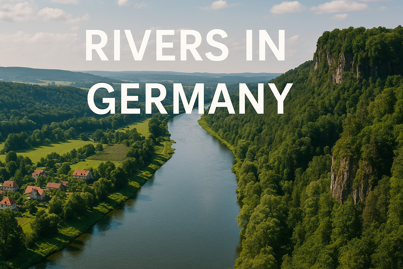
Rivers in Germany: Geography, Ecology & Human Impact
Explore rivers in Germany—from Alpine springs to North Sea estuaries. Learn about their geography, ecology, threats, and role in German life.
Rivers in Germany are far more than winding bodies of water—they are highways of history, veins of biodiversity, and shapers of dramatic landscapes. From the glacial peaks of the Alps to the flat shores of the North Sea, these rivers have carved valleys, sustained civilizations, and continue to power Europe’s heartland today. Whether you’re tracing the mighty Rhine or exploring the tranquil Spree, Germany’s rivers tell a story of nature, culture, and change.
🗺️ Geography & Geology
Germany lies at the crossroads of several major European geological zones—from the rugged Alpine forelands in the south, through the Central Uplands, and onto the North European Plain. Its rivers reflect this topography.
The southern rivers (e.g. the Isar, Inn) begin in steep alpine terrain, with rapid flow and narrow valleys, while the central rivers like the Main and Moselle meander through ancient folded mountains and wine-soaked valleys. To the north, rivers like the Elbe slow their pace across glacial plains and fenland, finally spilling into the North Sea and Baltic Sea.
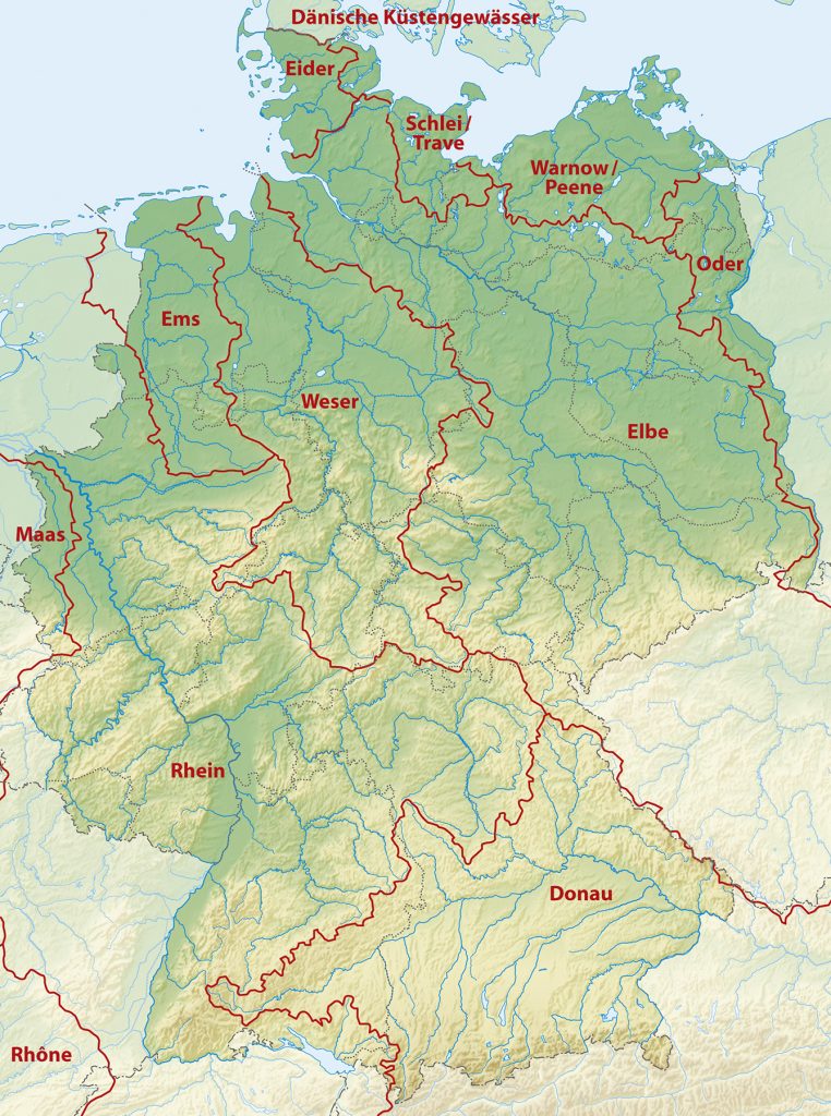
🌊 Major Drainage Basins and Catchments
Germany’s river systems are divided into five major drainage basins, each flowing into different seas:
- North Sea Basin: Rhine, Weser, Ems, and Elbe
- Baltic Sea Basin: Oder, Peene
- Black Sea Basin: Danube and its German tributaries
- Atlantic Basin (via Meuse and Scheldt): Small portion in the far west
- Endorheic/Minor Basins: Tiny internal catchments without sea outflow
The Rhine River Basin dominates western Germany, while the Danube (Europe’s second-longest river) begins its journey in the Black Forest, heading eastward into southeastern Europe.
💧 Hydrology
Germany’s rivers are fed by a mix of glacial meltwaters, rainfall, and groundwater springs. The southern rivers, sourced from the Alps and uplands, show distinct seasonal flow variations—raging in spring from snowmelt, calmer in winter.
Meanwhile, northern lowland rivers such as the Havel or Eider have more consistent flow, influenced by rainfall and slow-moving terrain. Flood control infrastructure, like the Rhine’s dikes or Danube’s retention basins, plays a major role in water management.
Germany’s rivers also underpin hydropower, navigation, and urban water supplies—intertwining natural flow with intense human usage.
🌿 River Ecology: From High Mountains to Coast
From ice-cold mountain torrents to brackish estuaries, Germany’s river ecosystems span remarkable gradients:
- 🐟 Alpine rivers: Home to trout, grayling, and cold-adapted invertebrates.
- 🍃 Upland streams and middle reaches: Rich in aquatic plants, dragonflies, and beavers.
- 🌾 Lowland rivers: Broad floodplains with herons, carp, and reeds.
- 🐦 Estuaries: Crucial bird habitats, such as the Elbe or Weser delta wetlands.
Many rivers support rare and endangered species like the European otter, freshwater pearl mussel, or salmon—the latter returning to restored stretches of the Rhine after decades of absence.
🏔️ River Features: Sculptors of the Landscape
German rivers have chiseled the land into iconic shapes:
- Rhine Gorge (Mittelrhein): A UNESCO site of steep cliffs, castles, and vineyards.
- Elbe Sandstone Mountains (Saxon Switzerland): Striking rock formations carved by the Elbe.
- Danube Sinkhole: Where parts of the Danube mysteriously vanish into karst limestone.
- Moselle Valley: Serpentine river bends through sun-drenched wine country.
- Triberg Waterfalls: Among Germany’s highest, cascading from Black Forest streams.
Even cities—like Hamburg, Cologne, and Dresden—grew around the dynamic, sometimes destructive, action of rivers.
🏘️ People Along the Riverbanks
Rivers in Germany are deeply entwined with its human story. Early Celtic, Roman, and Germanic settlements sprouted beside riverbanks for freshwater, food, and transport.
- The Rhine became the Roman Empire’s frontier.
- The Danube linked central Europe to the Black Sea world.
- Medieval towns like Regensburg, Heidelberg, or Bamberg owe their charm and economic rise to their riverside positions.
- Today, rivers anchor cultural events—from Rhine in Flames festivals to Elbe Philharmonic concerts.
Industrialization brought barges, locks, and canals—but also pollution and disconnection from nature.
⚠️ Threats and Conservation Challenges
Despite recent improvements, Germany’s rivers face serious challenges:
- Pollution: Agriculture runoff, microplastics, and industrial discharges degrade water quality.
- Hydrological alterations: Dams, channelization, and dredging disturb sediment flow and fish migration.
- Climate change: Brings both droughts (as seen in the shrinking Rhine in dry summers) and extreme floods (like the 2021 Ahr River disaster).
- Biodiversity loss: Many aquatic species are endangered or regionally extinct.
However, hope flows: major river restoration projects, like those on the Isar in Munich, and fish ladder systems on the Rhine, signal a growing effort to let rivers live again.
🌍 Conclusion
The rivers in Germany are living corridors of history, ecology, and transformation. They shape the land and its people, from the misty Alps to the salty North Sea. But they are also vulnerable—requiring thoughtful stewardship, policy, and public love.
To understand Germany, follow its rivers. You’ll uncover ancient stories, dynamic nature, and the pulse of a nation always in motion.