What Are Aquifers? Understanding Their Vital Role in River Systems
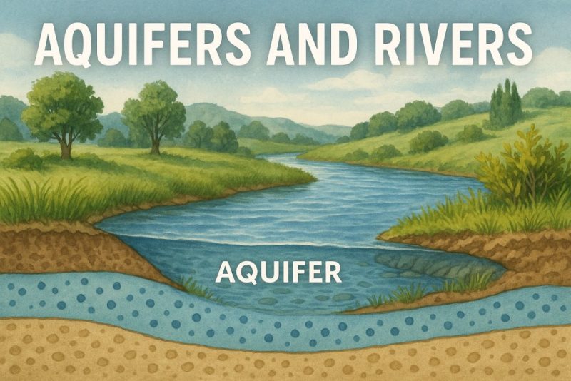
Discover how aquifers and rivers are deeply connected in Earth’s water cycle. Learn how underground water reservoirs sustain rivers, ecosystems, and human life—and why protecting them matters.
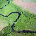
Did you know rivers have secret allies flowing silently underground?
While rivers dance across the surface of the Earth, there’s a hidden world below—aquifers, vast underground reservoirs tucked between layers of sand, gravel, and porous rock. These unseen stores of water act like natural sponges, slowly collecting rain and runoff over time. They might be out of sight, but their role is crucial: aquifers silently support rivers, ecosystems, and even entire civilizations.
What Does an Aquifer Really Look Like?
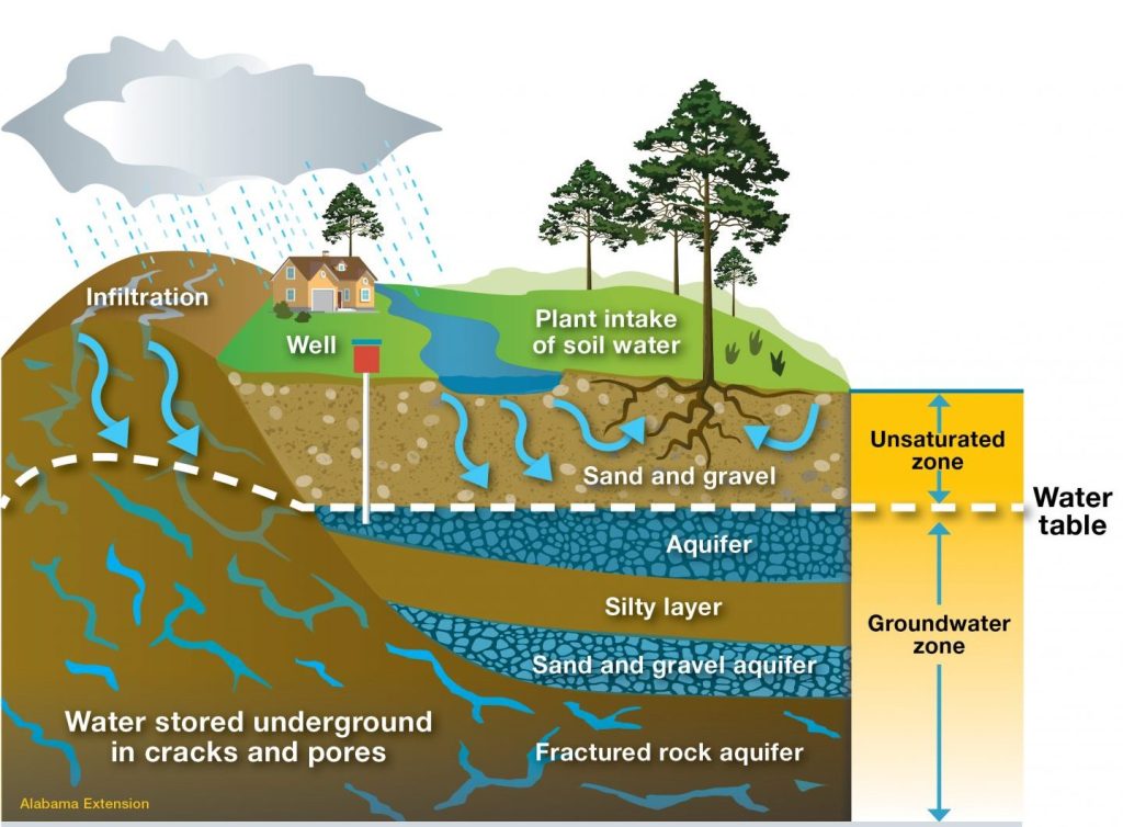
Aquifers are underground water-bearing formations that store and transport groundwater. Rain, snowmelt, and surface water slowly seep down through the soil, percolating into these porous layers where it can remain—sometimes for months, sometimes for thousands of years.
When people picture groundwater, they often imagine vast underground lakes or hidden pools. And in some special cases—like in karst regions (like Croatia)—this is true. In areas with limestone bedrock, water can collect in cave-like chambers, forming underground rivers or lakes.
But most aquifers are quite different.
They’re not hollow spaces filled with open water, but rather layers of rock, gravel, sand, or soil (sediment) filled with tiny pores, like a sponge. These pores may seem small, but together they can store enormous amounts of water.
Above the water table, the pores are mostly filled with air.
Below the water table, those same spaces become saturated with water.
Rain and runoff slowly recharge these aquifers, seeping through the soil and filtering down into the porous layers below—silently storing freshwater beneath our feet.
Types of Aquifers
Aquifers aren’t all the same—they come in different forms, shaped by the geology of the land:
Gravel and Sand Aquifers
These are the most common. Picture layers of loose pebbles or coarse sand, where water flows relatively freely between the grains.
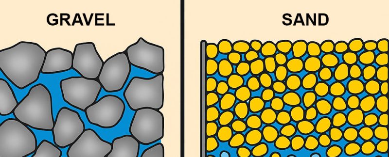
Gravel Aquifers – Rapid Flow
Gravel layers have large, coarse particles, leaving plenty of open space between them. Water flows through quickly, making these aquifers highly permeable and excellent for well extraction. But they also recharge and drain fast—less reliable during dry spells.
Fine Sand Aquifers – Moderate Flow
Fine sand particles are smaller and more compact. Water moves at a moderate rate, making these aquifers a balance between storage and flow. They’re common in many natural settings and offer stable, if slower, recharge.
Loam Aquifers – Moderate but Variable
Loam is a mix of sand, silt, clay, and organic matter, and the flow of water through it depends on the proportions. Generally, it offers moderate permeability, but holds onto water better than gravel. These aquifers may not provide fast flow but can sustain water longer.
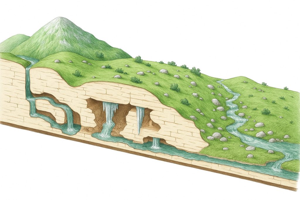
Karst Aquifers
Found in regions of limestone or dolomite, these are carved by centuries of water erosion into a labyrinth of caves, sinkholes, and underground streams. Water flows through them rapidly but unpredictably.
Fractured Rock Aquifers
In hard, crystalline rock like granite or basalt, water seeps through fractures and faults—narrow cracks that act like hidden veins.
Confined vs. Unconfined Aquifers
Not all aquifers are created equal—some lie close to the surface, open to the sky and rain, while others are trapped deep below, sealed beneath layers of rock. These two main types are known as unconfined and confined aquifers.
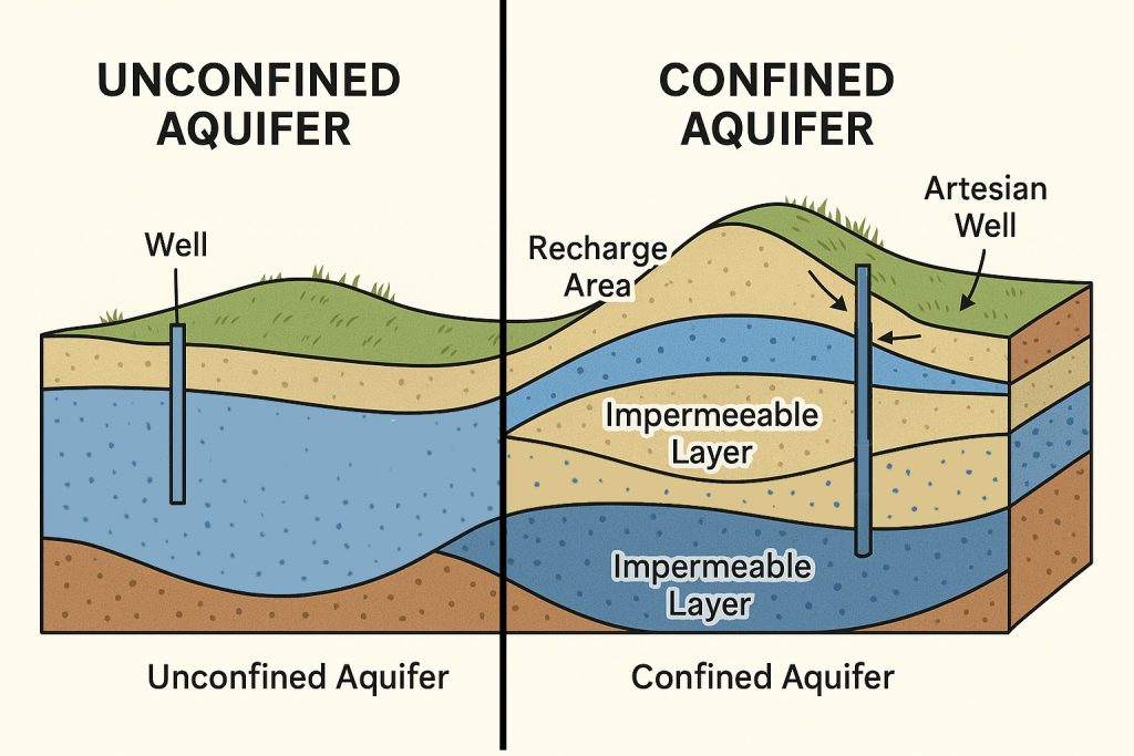
💧 Unconfined Aquifers
These are the most accessible and familiar.
Unconfined aquifers sit just beneath the surface, with no impermeable layer above them. They’re recharged directly by rainfall, rivers, or melting snow that seeps through the soil.
You can think of them as sandy sponges lying close to the Earth’s surface—easy to tap into, but also vulnerable to drying out or contamination.
Water table = the top of the aquifer
Common in: river floodplains, sandy coastal zones
Quick recharge but also quick to deplete
🧱 Confined Aquifers
These are pressurized aquifers, sandwiched between two impermeable layers of rock or clay that act like lids.
Water enters from a recharge zone far away and gets trapped, building pressure. When tapped by a well, this pressure can sometimes push water up to the surface without pumping—a natural fountain called an artesian well.
Deep and ancient
Better protected from contamination
Slower to recharge, but more stable over time
Together, confined and unconfined aquifers form a hidden backbone of freshwater beneath our feet—quietly supporting rivers, ecosystems, and human life across the globe.
Would you like a diagram to visualize how they work together under the surface?
🌊 How Do They Interact with Rivers?
Rivers and aquifers are two sides of the same water cycle coin:
Rivers and aquifers are deeply intertwined—two expressions of the same water cycle, constantly trading water above and below the surface.
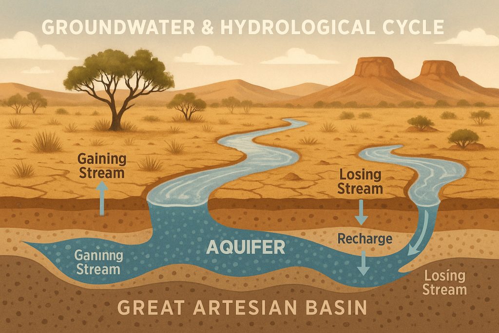
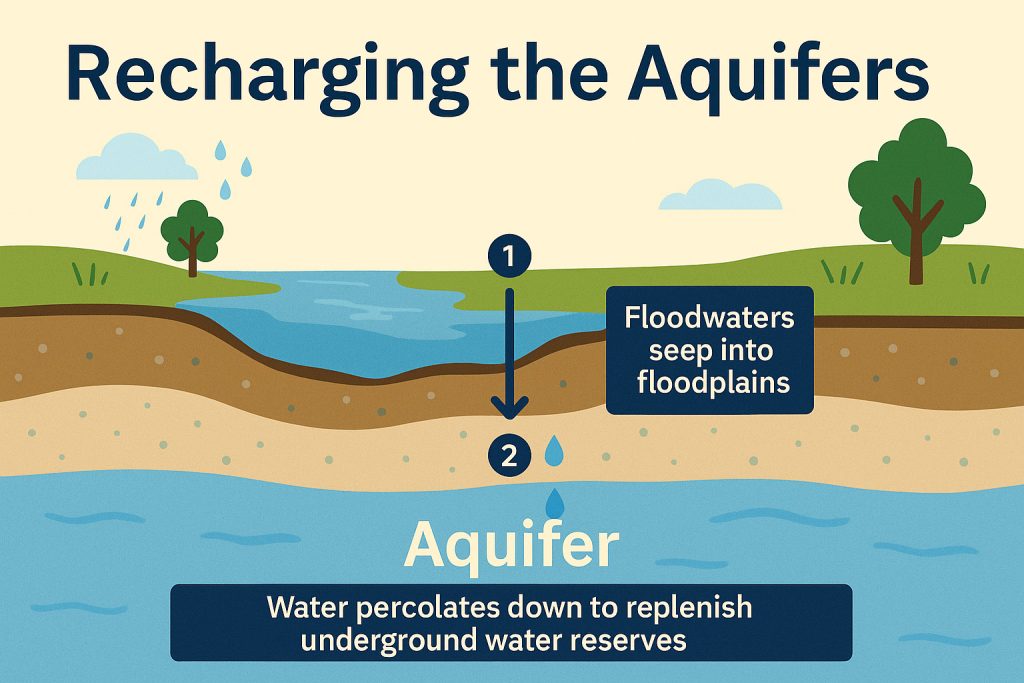
☔ In Wet Seasons: Rivers Feed Aquifers
When rainfall is abundant, rivers swell and overflow their banks. Some of this surface water infiltrates the ground, seeping through layers of soil and rock to recharge underlying aquifers. These periods act like a deposit into nature’s hidden reservoir, storing fresh water underground for the dry times ahead.
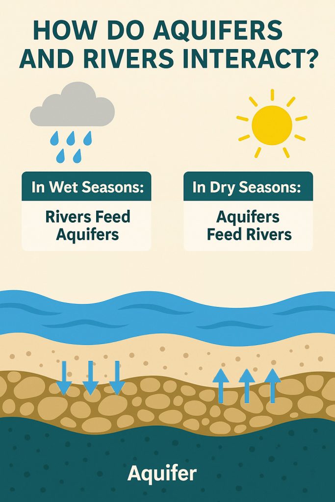
☀️ In Dry Seasons: Aquifers Feed Rivers
When rain disappears and riverbeds begin to shrink, aquifers quietly step in. The groundwater stored below the surface begins to seep back into the river, often through springs or unseen percolation. This baseflow of cool, filtered water sustains rivers during droughts, keeps ecosystems alive, and ensures some rivers continue flowing even when skies remain dry for months.
This dynamic creates a delicate balance—a hidden give-and-take between surface and subterranean water. It’s why a river can seem eternal, its stream bubbling long after the last rain has fallen. But when aquifers are overdrawn or disconnected by human activity, even the most persistent rivers can run dry.
Why Aquifers Matter
Though invisible, aquifers are among the most critical natural resources on Earth. These hidden water stores shape ecosystems, economies, and entire ways of life.
🌾 They sustain rivers, wetlands, and agriculture, especially in arid and semi-arid regions where rain is scarce and surface water disappears for months. Crops grow where rivers might not flow—thanks to the steady underground drip of groundwater.
🐟 They nourish ecosystems by providing cool, clean water year-round. This stable flow supports fish populations, amphibians, birds, and lush riparian vegetation—essential for biodiversity.
🚰 They quench the thirst of humanity. Nearly 2 billion people rely directly on groundwater for drinking, cooking, and sanitation—often via wells and boreholes in regions where surface water is unreliable or unsafe.
But this vital resource is under threat:
⚠️ Over-pumping for irrigation and industry is draining aquifers faster than they can naturally recharge, creating a ticking clock beneath our feet.
🏙️ Urban development and concrete sprawl seal the soil, blocking rainfall from soaking into the ground—and cutting off the aquifer’s supply.
🧪 Pollution from fertilizers, chemicals, and waste seeps downward, contaminating water that took centuries to store and making it unsafe for both people and wildlife.
When aquifers run dry, rivers shrink, wells go barren, crops fail, and wetlands vanish. The change is not just ecological—it’s cultural, economic, and deeply human.
🧭 Next time you cross a river or drink a glass of water—think of the quiet aquifer beneath you. It may be the river’s lifeline… and yours too.
Would you like this adapted into a carousel post with visuals, or would you prefer a long-form blog version with graphics and real-world case studies (like the Ogallala, Guarani, or Paris Basin aquifers)?